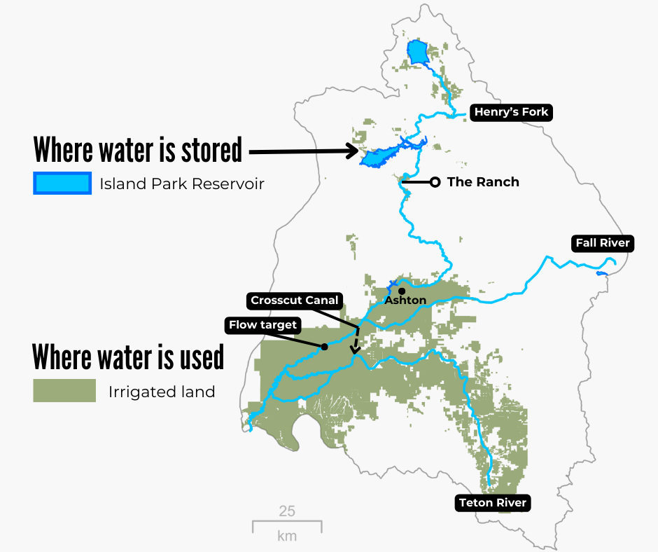
top of page

Losing Focus or Finding Our Center? HFF Discovers Island Park Reservoir is the Center of the Universe

Updated: Apr 16

At the Henry’s Fork Foundation, we believe in stewardship through science. When HFF was initially founded, our focus was largely on the fishery from Island Park to Riverside. In the 1980s, HFF did stellar work to install and maintain cattle fences to protect the riverbank from erosion on the Ranch. Our founders took on Washington to protect Mesa Falls from new hydropower development—and succeeded. In the 2000s, we facilitated the construction of the Buffalo River fish ladder for trout spawning migration and we continue to operate the ladder to this day. But in recent years, the Henry’s Fork Foundation has expanded its portfolio to include the lower Henry’s Fork, the Teton River, the South Fork, participate in basin-wide water management, and pursue water conservation on individual farms. Why?


This is a great question and one we hear often. Thankfully, it has a simple answer. Follow our logic here:

  • The quality of the fishery from Island Park to Riverside is dependent on Island Park Reservoir.

  • Who owns the water in Island Park Reservoir? Farmers.

  • Where are farmers? In the valleys, between Ashton and Rexburg, 40+ miles downstream.

  • Thus, all the water coming out of Island Park Reservoir is being sent downstream to the farmers who own it… and flowing right through the Island Park to Riverside fishery.


That’s why we work beyond the Caldera—in the lower watershed, on the South Fork, and with irrigators. If we want to benefit the fishery from Island Park to Riverside, we need to focus time and energy on Island Park Reservoir and collaborate with the folks who own its water. We have not lost focus. Instead, we have found our center.


Because in the Henry’s Fork watershed, Island Park Reservoir is the Center of the Universe.


FAQ: How does Island Park Reservoir impact the Caldera fishery?

A: Winter operations directly impact juvenile trout survival and the size of the trout population from Island Park to Riverside. Operations at other times of year can impact water quantity (how much water is in the river) and water quality (what the water looks and feels like) both on the reservoir and downstream. Summer operations also impact the size of the kokanee population upstream of Island Park Reservoir. Learn more in our Reading the Water StoryMap (https://arcg.is/1fi0Cn0).


FAQ: Who owns water in Island Park Reservoir?

A graph showing that 87% of water stored in Island Park Reservoir belongs to farmers in the Henry's Fork watershed, while the remaining 13% belongs to American Falls water users
Data from Idaho Water District 01 storage reports (1987-2022)

A: Island Park Reservoir was built in the 1930s for irrigation storage by the U.S. Bureau of Reclamation, which owns the dam. Fremont Madison Irrigation District (FMID) holds all of the rights to water that can be stored in Island Park Reservoir under the upper Snake River basin water-rights priority system. Although Island Park Reservoir physically fills every year, because FMID’s storage rights within the basin are junior, some of the water physically stored in Island Park can actually belong to irrigators with storage rights in American Falls Reservoir. For 1987–2022, on average, 87% of the water in Island Park Reservoir belongs to FMID and is designated for irrigation use in the Henry’s Fork watershed. The remaining 13% belongs to American Falls users and is sent outside the watershed for agricultural production elsewhere in Idaho. Some small fraction of water can contribute to the upper Snake River basin’s contribution to spring-time flow augmentation in the lower Snake River for endangered salmon and steelhead migration.


FAQ: Why does HFF spend time thinking about the Teton River?

A: Teton River water users rely heavily on Island Park Reservoir storage for irrigation, since natural flow in the Teton River drops dramatically once snowmelt ends.  At Chester Dam, the Crosscut Canal delivers this Island Park water from the Henry’s Fork to the Teton River during the summer farming season. When water is needed in the Crosscut Canal, it typically generates an increase of around 200 cfs in outflow from Island Park Reservoir.


A map of the Henry's Fork watershed highlighting Island Park Reservoir as a storage facility in the headwaters and irrigated land in the lower watershed. Attention is drawn to the Crosscut Canal and flow target locations in the lower watershed.
Map of the Henry's Fork watershed relative to major water management levers.

FAQ: Why does HFF work in the lower watershed?

A: The lower Henry’s Fork—specifically the 2.5-mile reach downstream of St. Anthony—is home to irrigation canals that can divert up to 800 cfs from the river during peak demand in July and August. To ensure the river stays wet and fish habitat is protected downstream of these canals, the Henry’s Fork Drought Management Planning Committee (of which HFF is a member) uses an informal, non-binding irrigation-season flow target. The flow target has been in place since the 1970s and has undergone multiple revisions. HFF research initiated a new flow target in 2020. During irrigation season (April-November), outflow from Island Park Reservoir is adjusted as needed to meet irrigation demand (including Crosscut Canal delivery) and the flow target. The new flow target has resulted in slightly lower outflow from Island Park, thus contributing to water savings in Island Park Reservoir. This results in more preferable flows in the Harriman State Park reach during the summer fishing season and higher winter flows for juvenile trout recruitment in Box Canyon.


FAQ: When did HFF “discover” Island Park is the Center of the Universe and decide to work beyond the Caldera?

Island Park Reservoir with low water levels and exposed sediment that is typically underwater. The sky is stormy and blocking the afternoon sun. The first wisps of rain are starting to fall.
Island Park Reservoir on September 29, 2016

A: Drought conditions in 2016, quite frankly, kicked our ass. Island Park Reservoir was almost completely drawn down and anglers experienced the worst water quality seen both in the reservoir and downstream since 1992. So we took a long, hard, scientific look at our programs and asked ourselves—What impact is our current work having? What did we miss? And how can we prevent this in the future? The answer was sobering. Our Caldera-centric work was improving the fish population by 2–3%, winter flow by 5–10%, and water quality by a dismal 0%. To avoid such a dreadful fishing season in the future, the data indicated that we needed to keep Island Park Reservoir at least 40% full every year. And to achieve that, we needed to engage farmers, irrigators, and water managers and work where they use and manage the water. The summer of 2016 may have knocked us down, but it forced us to find our center of gravity—Island Park Reservoir is the Center of the Universe, and is now the center of our scientific programming.


FAQ: Is this new approach actually making a difference for the Caldera fishery?

A: Yes. Since we expanded our programs in 2017, we have made an enormous difference. We have increased the amount of water stored in Island Park Reservoir at the end of the irrigation season by 26,000 acre-ft (19% of reservoir capacity) and increased winter flow by 114 cfs (42%). These water savings benefit fish populations and water quality, and enhance the fishing experience by reducing summer outflow temperatures, turbidity, and sediment load. Our success has also demonstrated financial benefits to our irrigation partners and better achieved water management goals—further solidifying our ability to find mutually beneficial solutions for agriculture and anglers alike, and further grounding our collaborative relationships. Of course, our success in saving water in Island Park Reservoir does not minimize the need to continue to maintain fences at Last Chance and Wood Road 15 or operating the Buffalo River fish ladder. But focusing on how Island Park Reservoir is the Center of the Universe will continue to be a centerpiece of our science and strategy to protect the Henry’s Fork and its trout fishery.


bottom of page